Winter has felt oddly gentle in many northern cities, yet high above the Arctic something far more dramatic is unfolding.
Forecasters are tracking a powerful disruption of the polar vortex that could flip late-winter weather on its head across parts of Europe, North America and Asia in the coming weeks.
What is actually happening above the Arctic?
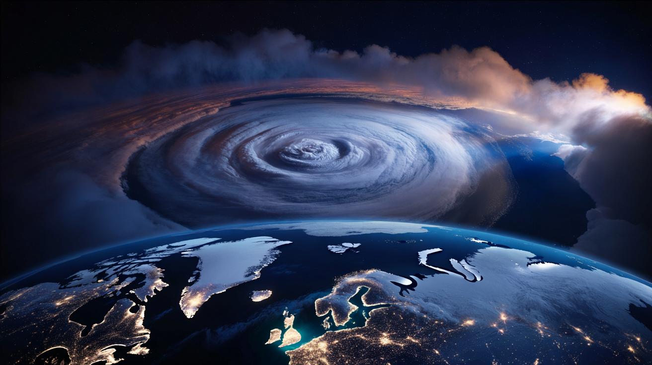
Far above the storms and clouds we see every day, around 30 km up in the stratosphere, sits the polar vortex. It is a ring of very fast winds that circles the Arctic each winter, normally spinning west to east and helping to keep the coldest air locked near the pole.
Most years, this stratospheric vortex remains compact and reasonably stable. This February, it is doing anything but that.
A major sudden stratospheric warming is underway, with temperatures over parts of the Arctic stratosphere projected to jump by 40–50 °C in just a few days.
That rapid heating event, known as a sudden stratospheric warming (SSW), is on track to slam the brakes on the polar vortex. Model data from several major forecast centres show winds at around 10 hPa – a key level for monitoring the vortex – not only weakening, but actually reversing direction from strong westerlies to strong easterlies.
For February, that level of reversal is close to unprecedented in the modern record. In some simulations, the once-coherent vortex splits into two smaller circulations. In others, it is shoved off the pole entirely, displaced toward Siberia or northern Canada.
Why February makes this event so unusual
Sudden stratospheric warmings are not rare in a general sense. On average, one major event occurs every couple of winters in the Northern Hemisphere. What stands out this time is both the timing and the intensity.
SSWs tend to peak in January. Having such a strong disruption in late February means the atmosphere is being shaken just as the surface in many regions is already softening toward spring. Soil is thawing, snow cover in mid-latitudes is patchy, and daylight is growing longer.
A nearly record-strength SSW at this stage of winter increases the chance of sharp clashes between lingering Arctic air aloft and a surface that has begun to warm.
Those clashes can fuel turbulent weather: rapidly deepening low-pressure systems, heavy wet snow, ice storms and dramatic temperature swings rather than a simple, long-lasting freeze.
From the stratosphere to your street
One of the trickiest parts of an SSW is explaining the delay. The disruption begins high above our heads, and the effects at ground level do not show up instantly.
- Typical lag: 10–20 days before clear changes appear in surface weather patterns.
- Main impact zones: often Europe, northern Asia, Canada and the northern United States.
- Key symptom: a highly distorted jet stream with more pronounced north–south meanders.
Once the polar vortex weakens or splits, the cold air it usually traps near the Arctic can leak southward in lobe-shaped pockets. The jet stream, which steers storms, tends to buckle into larger waves. This can lock in “blocking highs” over some regions and repeated cold plunges over others.
For people on the ground, that can mean a sudden shift from mild, early-spring conditions to late-season blizzards, biting wind chills, or persistent grey, chilly weather.
Crucially, a polar vortex disruption does not guarantee extreme cold in every country. Instead, it loads the dice. Some regions will end up on the cold, snowy side of the new pattern; others might sit under milder, wetter conditions, or see rapid oscillations from one to the other.
Recent history: 2018 and 2021 as cautionary tales
Two events over the last decade offer a rough sense of what an SSW-connected disruption can do when the surface pattern lines up unfavourably.
| Event | Region most affected | Main impacts |
|---|---|---|
| “Beast from the East” (2018) | UK and western Europe | Intense cold, deep snow, transport chaos, school closures |
| February freeze (2021) | Central and southern US, especially Texas | Severe cold far south, power failures, water system damage |
Both of those episodes were linked, at least in part, to disrupted polar vortex conditions and a strongly contorted jet stream. The current February setup does not necessarily repeat those exact patterns, but it sits in the same family of events that can turn a quiet late winter into a high-impact one.
What forecasters are watching right now
Behind the scenes, meteorologists are poring over ensemble model runs – dozens of slightly different simulations of the atmosphere – looking for where the emerging cold lobes could settle.
Several features are under close scrutiny:
- Vortex split vs displacement: A clean split often favours strong cold outbreaks into Eurasia and North America. A mere shove of the vortex toward Siberia can give Europe a higher chance of Arctic air.
- Blocking highs: Persistent high pressure over Greenland or Scandinavia can act as a wall, forcing cold air to spill toward western and central Europe.
- North Atlantic pattern: A negative phase of the North Atlantic Oscillation (NAO) tends to support colder conditions over parts of Europe.
Forecast centres are already flagging an unusually high risk of a negative NAO pattern following this SSW, which often correlates with colder, more unsettled weather across much of Europe and parts of eastern North America.
That said, the precise location of the sharpest cold remains uncertain until the stratospheric signal fully couples with the troposphere – the layer from the ground to around 10–15 km where everyday weather happens.
Climate change and a wilder kind of winter
The phrase “polar vortex” tends to spread fast on social media, and it often drags climate debates along with it. Scientists are careful here: SSWs have always occurred, long before human-driven warming. They are part of the natural variability of the atmosphere.
Where climate change does seem to matter is in the background conditions in which these events now unfold. Average winter temperatures are higher. Sea ice is thinner and less extensive. The air can hold more moisture. Snow cover in mid-latitudes is less stable and melts faster when a thaw arrives.
That mix can turn a cold shot linked to a polar vortex disruption into a messy, high-impact episode featuring heavy, wet snow, freezing rain, rapid meltwater and ice, rather than the long, dry cold spells remembered from past decades.
There is ongoing research into whether a warming Arctic might be altering the frequency or character of SSWs, but there is no firm consensus yet. What is clearer is that societies built around more predictable seasons now face sharper weather swings, including in late winter.
What this could mean for your bills, travel and mood
For households and local authorities, the most immediate concerns are energy demand, transport and basic safety. A strong, late-season cold snap can strain gas and electricity networks that have just eased off their peak winter loads, especially in regions with ageing infrastructure.
Travel is another pressure point. Airlines, rail networks and road operators have to adjust staffing and equipment quickly if forecasts hint at heavy snow or ice just as they were shifting toward spring schedules.
On a more personal level, there is the emotional whiplash. Many people mentally pivot to spring by mid-February. A return to bitter winds and dark afternoons can drag on mood and sleep, particularly for those already prone to seasonal depression.
- Keep one genuinely warm coat, hat and gloves within easy reach for the next month.
- Leave winter tyres and ice scrapers in place a little longer if you drive.
- Check on neighbours or relatives who may struggle with a sudden temperature plunge.
Key terms worth unpacking
Sudden stratospheric warming (SSW) describes a rapid increase in temperatures high in the stratosphere over the polar region, typically over several days. It is often accompanied by a reversal in the usual west-to-east winds around the pole. That disruption tends to cascade downward and alter weather patterns weeks later.
Polar vortex is the name for the large-scale, cyclonic circulation of cold air and strong winds that sits over the polar regions during winter. There is a separate, looser “vortex” in the troposphere, but the term in this context usually refers to the stronger, more organised stratospheric feature.
Jet stream is a fast-flowing river of air in the upper troposphere that steers weather systems. When the jet stream runs in a relatively straight west–east line, weather is often more predictable. When it bends into big north–south loops, regions can get stuck in prolonged cold, warmth, wet or dry spells.
What you can realistically do over the next 2–3 weeks
You cannot control the polar vortex, but you can reduce the amount it disrupts your life. Think of the coming 10–20 days as a window for sensible preparation rather than fear.
Use the warning about this rare February disruption as a prompt to tidy up winter jobs you meant to do anyway.
- Check pipe insulation and outdoor taps to lower the risk of burst pipes if frost returns.
- Clear gutters and drains so that any quick switch from snow to heavy rain does not back up into your home.
- If you rely on medication, avoid running your supply down just as a potential storm window approaches.
- Consider flexible ticket options for any late-February or early-March travel through snow-prone hubs.
On the mental side, expect a last twist from winter. Accepting that one more proper cold spell could arrive reduces the sense of shock if and when the forecasts suddenly fill with blue and purple shading.
By early March, forecasters will have a clear view of how this extraordinary February SSW played out. For scientists, it will be a rich case study in how a heavily disrupted polar vortex behaves in a warming climate. For everyone else, it may be remembered as the year winter pretended to be over – and then came back for one more round.